Research on the Effect of “Wind Erosion” on Lunar Surface - MUST Makes New Achievements in the Application of the Scientific Data of the Chang'e-4
13/07/2021
13/07/2021
Wind erosion, namely the erosive action of the wind, is one of the basic geological processes on the surface of terrestrial planets with atmosphere. The Moon is a celestial body without atmosphere, and, under normal circumstances, it is difficult for researchers to study the effect of wind erosion on the surface topography of the Moon. However, during the landing of the spacecraft, the plume produced by the variable-thrust engine will create an intense impact on the lunar surface, leading to the rapid transportation of dust and erosion on the lunar surface. Therefore, the soft landing process of the detector provides an important opportunity for researchers to study the wind erosion process on the surface of the celestial bodies without atmosphere.
Recently, the scientific research teams led by Associate Professor Zhang Xiaoping at the State Key Laboratory of Lunar and Planetary Sciences and the Macau University of Science and Technology (MUST) adopted an innovative method combining image analysis and numerical simulation to analyze the data of the Chang'e 4’s landing camera and omnidirectional camera, and obtained key data such as the divergence angle and amount of the lunar dust blown up, the depth of lunar soil erosion, and the range of erosion, during the landing of the Chang’e 4 lander. Participating in the research are PhD student You Jilin of the MUST, Senior Engineer Li Cunhui and Engineer Zhang Haiyan of the Lanzhou Institute of Physics (LIP), and, researcher and Executive Director of the Chang'e 4 Detector Project Zhang He.
The maximum divergence angle of dust measured by the research team using the Chang'e 4 landing image is above 7°, which is greater than the that of about 3° obtained on the simulated horizontal lunar surface. This is mainly because Chang'e 4 landed on an inclined surface of 4~5°. Furthermore, the measured plume erosion range is much larger than the estimated value of the erosion model, indicating that the previous erosion model needs to be improved, and important factors such as local topography, distribution of dust launching angles, and the mechanical properties of the lunar soil also cannot be neglected.
The analysis results based on the landing image of Chang'e 4 not only tested the existing plume-dust erosion model and presented an optimization method for the improvement of the model, but also provided guidance for the selection of engineering strategies for subsequent lunar exploration missions. For example, lunar dust would start to be blown up when the nozzle of the Chang'e 4 is 13m above the lunar surface, therefore, a lunar lander similar to the Chang'e 4 should select a landing site at an altitude of more than 13m to avoid the influence of dust. The measuring of the maximum divergence angle of dust and the position where the dust has been blown up (internal erosion radius r0) can be used for the estimation of the impact range of the dust blown up by the landing, providing a reference for the dust-proof design in subsequent missions. Moreover, the analysis also indicated that the erosion depth of the lunar soil is positively correlated with the height of the local terrain, in other words, from the perspective of engineering safety, the lander should first land in the flat area of the lunar surface in order to reduce the adverse influence of dust on the equipment on the lander.
The research results, with the title “Analysis of plume-lunar surface interaction and soil erosion during the Chang'E-4 landing process”, were published in Acta Astronautica. The paper was highly praised by reviewers——“This is an extremely interesting subject. It is highly important research and it represents crucial improvements in technique. It is an excellent manuscript on a crucially important topic. I give it my highest recommendation to be published”. The research results were also introduced on the official Weibo and WeChat account of the “China Lunar Exploration Project” (CLEP), the official WeChat account of the “Planetary Science” and other platforms. This work was funded by the Macao Science and Technology Development Fund (FDCT) (008/2017/AFJ, 0042/2018/A2) and the National Natural Science Foundation of China (11761161001, 41941001) and other project funding.
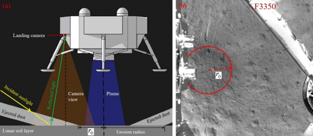
Picture 1: (a) Schematic diagram of dust erosion; (b) Data of the Chang'e 4’s landing camera
Reprinted from Macau University of Science and Technology :https://www.must.edu.mo/news/39219-article07121716
Office address: Avenida do Infante D. Henrique, No. 43-53A, Macau Square, 8th Floor, Unit C and 11th Floor, Unit K, Macao (To apply for project funding, please go to 11th Floor, Unit K)
Office hours: Monday to Thursday: 9:00-13:00, 14:30-17:45;Friday: 9:00-13:00, 14:30-17:30;Tel.: 28788777
Copyright(C) 2021 ALL right reserved.
Office hours: Monday to Thursday: 9:00-13:00, 14:30-17:45;Friday: 9:00-13:00, 14:30-17:30;Tel.: 28788777
Copyright(C) 2021 ALL right reserved.